Devil’s Canyon/Hong Ditch/Ketch Mine Tour
This historic, and varied trail/destination has SO MANY aspects to it, I thought I’d break this into sections. I start with a section on respect and maintaining access, then the incredible history and also, some alternate hikes. Google Earth continues to have poor imagery for this area at the moment, but Bing Maps has slightly better imagery taken in the winter that helps define trails, if you need.
2022 NOTE: This area has now been extensively logged on the lower slopes, so the entire entrance has been reshaped. However, the history lesson below remains relevant, and placer advice. I’ve added a kmz file for viewing on google earth, which is still bad for this area. You can also import the kmz to your phone if you use an app. If you don’t have a phone app to add to the fun of navigating I suggest you try GAIA. It is highly rated, works great, it’s super simple, very intuitive, and easy to import , track and export files from(so you can see where you went on Google Earth). The free version is simple but rich, it works offline, and it has good, clear topo information. KML files import easily.
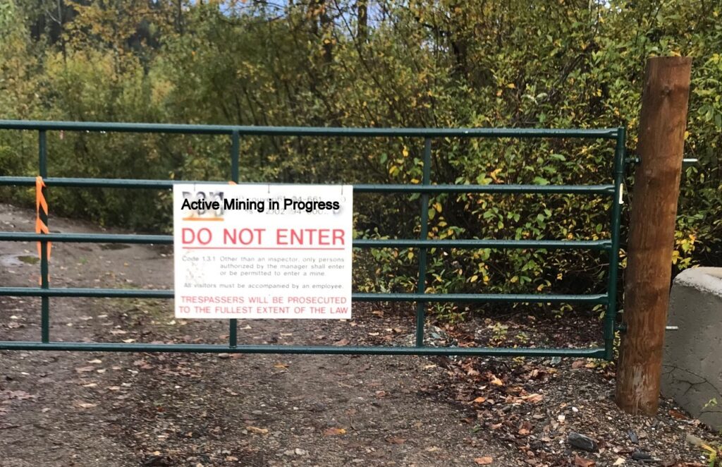
HOW TO GET STARTED: Locals like Bob Merta and Wolfgang Hoffmeier have done an excellent job of keeping you from getting lost on this trail, which starts just over 7 km west of the Frog on the Bog. People typically start from the placer driveway next to ManMade creek and winter hikes go up past a snowed-in locked gate. However, the parking along the hwy is problematic, due to traffic and lack of nearby pullouts. Most people try and park near the first ‘nopost’ on the opposite side of the hwy, but it doesn’t take long to fill that space and it’s vulnerable to snowplows. This route is not currently available in any other season than winter due to placer activity.
For access, there is also another, very interesting winter route with much better parking at the Slough creek FSR just at the bottom of Devil’s Canyon. From here the original Ketch Flume gulley runs uphill. It starts with a 50 m bush bash, which someone may clear soon so that this much more findable and preferable parking/hiking spot can be used to its full winter advantage by all skill levels. I will update this page as this access improves.
WHY THIS IS A FUN ROUTE: The route is well marked, and has unique views. Here’s the KML with a little addition to make the route home different than the route out.
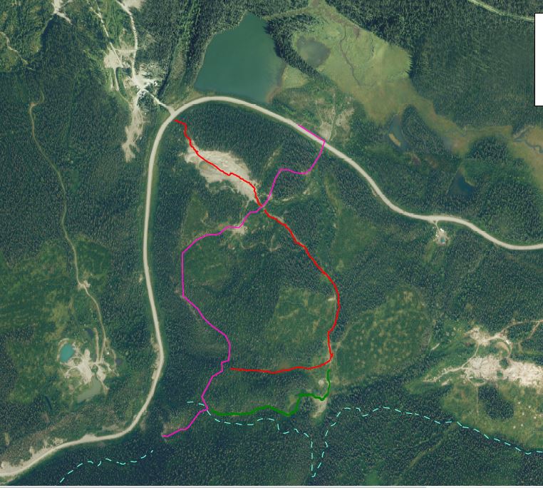
Green is currently a more difficult alternate route.
The blue dotted lines are the approximate locations of the Hong and the Canyon Ditchlines.
If you don’t own Bill Hong’s book, ‘And So…That’s How It Happened’, you better go buy one! This local book of mining lore, still published by his children is available at a few outlets including the Frog On The Bog in Wells. It adds a wonderful historic dimension to all the places you hike. I have included some photos from that book because of the magic it adds to the exploration of our country.
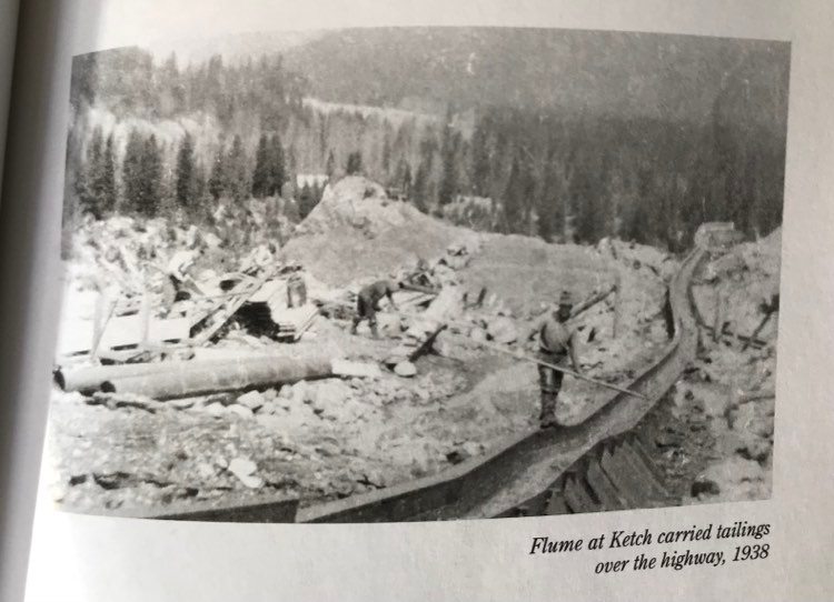
Before you start: Imagine in the summer, after you descend the canyon and swoop by the entrance to the Slough Creek FSR, there is immediately an old mostly flattened gravel pile on your left. That pile is the tailings pile from the Ketch Flume. The photo below, is taken leaving Wells just before you turn up the canyon. The Ketch is on the left, the viewer is about to turn the corner into Devils Canyon, but they have to drive under the Ketch Flume and admire the mixed gravel waterfall cascading off to the right and creating a massive pile of waste rock, that is still visible but now mostly bull-dozed away.
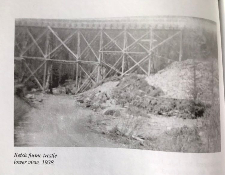
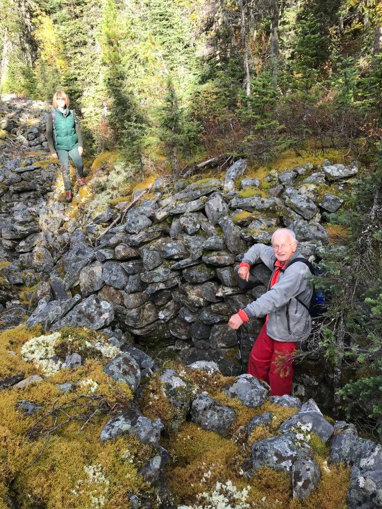
If you park at Slough Creek and hike up the slot created for the Flume you can still see volumes of rotting wood from that trestle and flume that slowly decayed and collapse in-place. Portions were still standing as little as 20 years ago. When you arrive at the top of that cut and turn right to follow your old route up to the canyon bluffs, or if you have come up the mine road and reached this first flat ground after passing the cabin, you can look back along this passage, pull out Hong’s book and look at this photo:
This photo is almost the same view today. Here you are looking along the top of the flume, as it passes down this gut and shoots across the hwy to the tailing pile at your starting point today. There are more pictures of the Ketch in the book to let you really grasp the enormity of the project that was and is the Ketch Mine.
Off you go, on the trail, enjoying the view from the lower bluffs and being careful to make sure your dog doesn’t happily slide over the edge to disaster! Eventually you pass a small smooth gulley, climb a ridge and stand near the end of the Hong Ditch overlooking Devil’s Canyon. The Hong Ditchline is a construction marvel. It followed in the inspiration of the Fook trestle, built in the 1870s and still visible as late as the 1820’s despite having not a single nail in its construction.
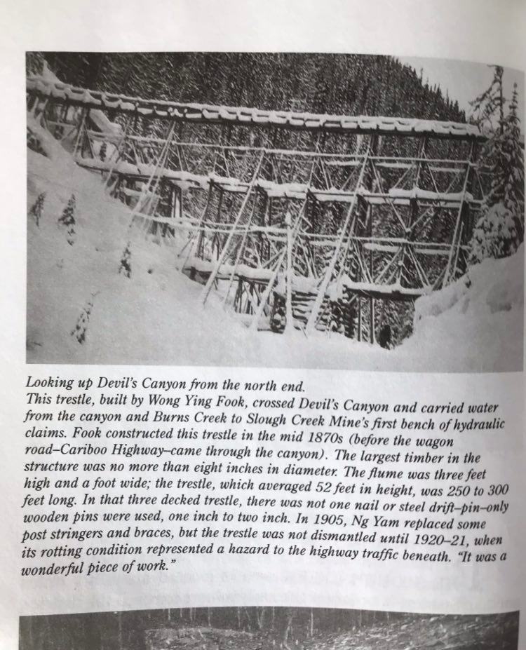
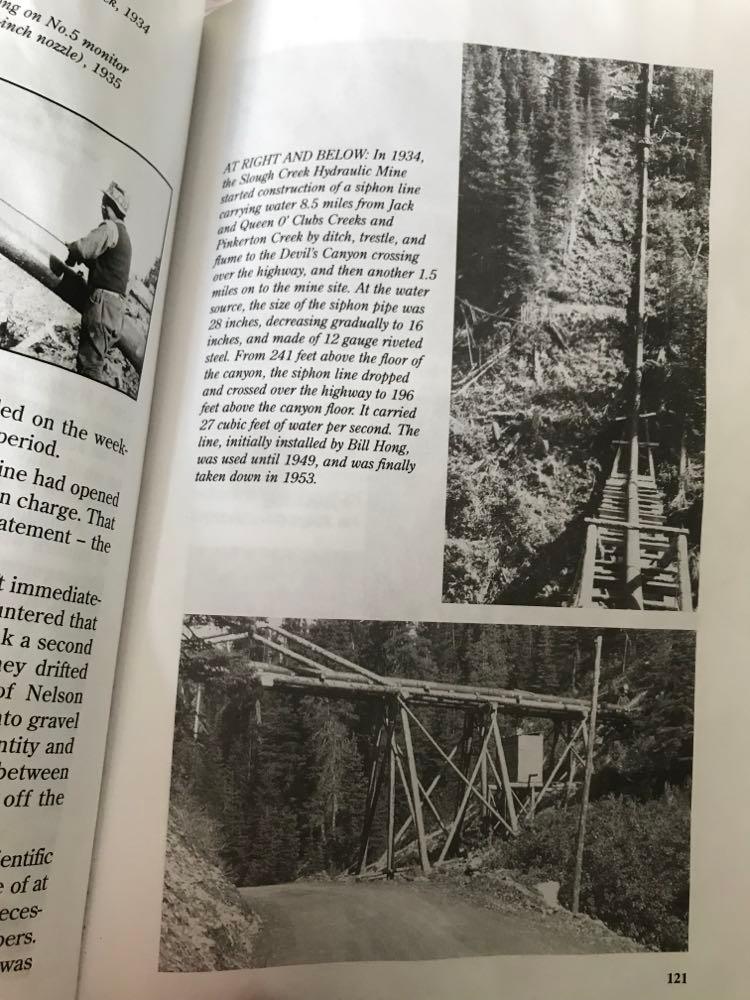
Bill Hong’s goal was similar. He succeeded in bringing water 16 km along hand-dug ditches, dozens of trestles, and across several mountain faces, including crossing Devil’s Canyon with the giant siphon line to leave the Jack O Clubs watershed and deliver to the Nelson Creek Hydraulic Mine farther west along Slough Creek.
In the photo below, you can see Hongs siphon crossing Devils Canyon at the narrowest spot, and the upper image was taken by a photographer standing on the trestle itself and looking uphill to where you are standing at the lookout.
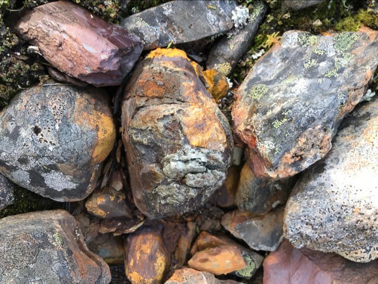
In the fall, the Hong ditchline is very obvious if you hike up to its level. It ends just short of the bluff, turns into a wooden sluice and wraps out onto the face in a now-hazardous collapse of rotting timbers on steep rock. In the other direction you can follow the ditch backward for km’s if it suits you, past rotted ditch-tenders cabins, abandoned trestle pipe, and the odd tool left behind. It’s easier to travel in the winter, but fascinating without snow. At the least, you can explore eastward along the high gulley just as far as Man-Made creek where the ditch would have crossed on a trestle straight across the mouth of the creek valley, to shorten the water trip. At this point, Manmade creek also has visible clearings from old placer mining and a mine/log road that sweeps you back to your route up, so if you want to make a circle route of your trip, this is a good alternative. (Red line on map photo)
For those of you with a pruner or folding saw, flagging and ambition, the horizontal portion of this route (which is only 500m) could be improved of deadfall and the odd dense section, to make it more obvious for travel. Once the clearing at Manmade creek is reached your way home/downhill along a road is obvious.
OTHER HIKES NEARBY:
Canyon Ditch: There is also a fascinating alternative to the Ketch hike. Start by parking at the red-roof pullout in the middle of Devils Canyon(across from the tumbling rock/scree bluff where people ski some times). If you walk down the hwy to the bottom edge of the lake below that pullout and cross the lake at that bottom edge, you’ll cross on an old sluice dam. 20 feet up the back side of the crossing. Here a ditchline begins running north, back to the bluff. This ditch originally started from the lake above this one, crossed the sheer bluff on trestle 20 feet above this lake and then changed to ditch that runs north all the way back to the Hong bluff also. I don’t know if it also fed Hong’s trestle, or the Ketch or had some other use, from some other period, but it is straight and true before it gets lost on the bluff face, where it probably switched to wood.
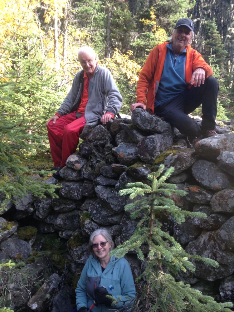
Canyon Stoneworks: Instead of following the Canyon Ditch back to the bluff, you can also climb just slightly higher, up a short draw angling right to see some of the most magnificent rockwork I have ever witnessed in the Cariboo. Miners built numerous tidy wasterock mountains here with narrow guts for ground sluices that shot over the bank and dropped into the little lake below. This is a relatively narrow ledge of flat ground and you will wonder what possessed people to work it so hard, but the impression is stunning and magnificent as you scramble southward and circle the back of the little lake back to your car. I would do this one in the summer or fall so you can see the construction hidden beneath the snow in the winter/spring.
MORE ABOUT PLACER MINES, THE LAW, AND COURTESY:
In our area, you are often traveling over an in-use placer claim that dates back over 150 years. Placer miners, in general, are hard working independent small business folk, with a lot of pressure from gov’t to navigate complicated mining law written that was written to protect public assets from multi-national corporate lawyers. Some of that law also threatens independent miners with liability when you ‘trespass’ on their operating workings. Rightfully so, this makes miners very nervous of trespass. So does the threat of vandalism and theft.
All sorts of entities lay claim to the same piece of public land. The logger claims the trees, the miner claims the ore, the trapper claims the fur, and so on, all on the same square feet of property that belongs to you, the tax-payer. For most people it’s helpful to compare mining to your understanding of logging of crown land. You can recreate on portions of forests and placer claims(crown land) that are in a state of rest, but for your own safety, are prohibited from access ‘active‘ logging blocks and also active portions of mine claims. All miners file a ‘Notice of Work’ for the specific portion of their claim that is being developed. All other portions of that same claim can be treated as normal crown land to the recreationalist.
It gets fuzzy fast when you try to define ‘inactive‘ on a mine claim. Is a claim active when it’s buried in snow? when it hasn’t been worked for years but the sign’s still up? when a claim is abandoned without reclamation? In the end, EMLI(BC Mines) doesn’t want you to hurt yourself on any land that is previously disturbed by mining. I’ve been told by a mines inspector that there is not statute of limitations on that concern for your safety. Unfortunately, given that definition, in the Cariboo, that would exclude you from almost every square inch of country. In fact, many actual hiking trails follow old mine roads, travel through hydraulic operations, and past old drifts and waste piles! Therefore EMLI is sensibly silent in pressing active enforcement of this point.
How to navigate a law that is ambiguous? First, understand, empathize and respect the awkward position of the miner caught in the middle of all this. You can try to lean on ‘common sense’, but it’s also important to politely respect the position of the people trying to make a living while obeying mining law. Erring on the side of giving-the-miner-relief-from-government-hassle is a good strategy for avoiding hassle for either of you.
In addition, Placer mines are not-infrequently subject to theft and vandalism. It can be nerve-wracking for the claim owner to see your car and steps leading into their claim. Are you scouting out their stuff to steal or break-in later? Should they go check? Also always assume they have a game camera hidden in the bush to protect their assets. Will they see you looking in camp windows, and trying doors? climbing on heavy equipment?, or otherwise raising their suspicions about your unknown intentions? For these reasons, it’s really helpful to stifle your curiosity about some things and just give a wide berth to modern equipment and installations, regardless of how snow covered and abandoned you may think they look.
So to summarize: In my experience placer miners are friendly generous people who want you to appreciate their own intimate relationship with the land and share in their enthusiasm for history and the natural environment….but they are invariably private, and appropriately suspicious and nervous of un-invited guests. When the claim-owner anxiously follows your trail, or looks at your picture on their hidden game cam, you want it to be blatantly obvious that your goals are completely recreational, respectful and without any sinister intention! Don’t block their gates, and do respect their efforts. That’s going to make their, the government’s, and all the rest of our lives much easier, and maintain casual access in an otherwise unnecessarily complicated legal environment that nobody wants to invoke.
Have a great snowshoe/ski!
4 Responses
Hi Dave,
These hikes sound really interesting and we are thinking of choosing one this weekend. What time allowance would you give to all these hikes. Thanks for sharing this info.
Jean
Hi Jean, Just a reminder that the Ketch Mine may still be open in the fall, by the miner and therefore not crossable for a hike. However, I highly recommend the Canyon hikes from the red-roof pullout mid-canyon. If you circle the lake, and enjoy the amazing things you see, it’ll take a couple of hours at least. You can’t get lost, but remember that this is a route, not a trail, so expect to brush a twig out of the way! Have fun and let us know how it goes! Dave
The Hong Viewpoint Snowshoe is also a two to three hour easy to moderate hike. Again, it depends on your exploration rate, whether you check out the alternate routes, and how many photos you take. Make sure you check out our other winter hikes we also posted on this blog, and feel free to contact us at the FrogOnTheBog for recent info and other trail options!
Thanks Dave for the interesting write up and history in your area…..and also the gentle reminder of the potential angst that us recreational snoops may cause others. Use of crown land a balancing act for sure.
Comments are closed.